


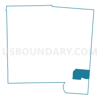
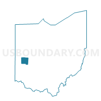
PRECINCT BETHEL EAST, Miami County, Ohio
About
Outline

Summary
| Unique Area Identifier | 650040 |
| Name | PRECINCT BETHEL EAST |
| County | Miami County |
| State | Ohio |
| Area (square miles) | 9.12 |
| Land Area (square miles) | 9.02 |
| Water Area (square miles) | 0.10 |
| % of Land Area | 98.86 |
| % of Water Area | 1.14 |
| Latitude of the Internal Point | 39.95690770 |
| Longtitude of the Internal Point | -84.09286490 |
Maps

Graphs
Select a template below for downloading or customizing gragh for PRECINCT BETHEL EAST, Miami County, Ohio


Neighbors
Neighoring Voting District (by Name) Neighboring Voting District on the Map
- Voting District BETHEL 7, Clark County, OH
- Voting District CARL 2, Clark County, OH
- Voting District CARL 3, Clark County, OH
- Voting District PIKE 1, Clark County, OH
- PRECINCT BETHEL SOUTH CENTRAL, Miami County, OH
- PRECINCT BETHEL SOUTH EAST, Miami County, OH
- PRECINCT BETHEL WEST, Miami County, OH
- PRECINCT ELIZABETH, Miami County, OH
Top 10 Neighboring County Subdivision (by Population) Neighboring County Subdivision on the Map
- Bethel township, Clark County, OH (18,523)
- Bethel township, Miami County, OH (4,843)
- Pike township, Clark County, OH (3,730)
- Elizabeth township, Miami County, OH (1,648)
Top 10 Neighboring Place (by Population) Neighboring Place on the Map
Top 10 Neighboring Unified School District (by Population) Neighboring Unified School District on the Map
- Tecumseh Local School District, OH (19,020)
- Miami East Local School District, OH (7,459)
- Bethel Local School District, OH (5,606)
Top 10 Neighboring State Legislative District Lower Chamber (by Population) Neighboring State Legislative District Lower Chamber on the Map
- State House District 79, OH (119,858)
- State House District 84, OH (116,799)
- State House District 72, OH (102,568)
Top 10 Neighboring State Legislative District Upper Chamber (by Population) Neighboring State Legislative District Upper Chamber on the Map
Top 10 Neighboring 111th Congressional District (by Population) Neighboring 111th Congressional District on the Map
Top 10 Neighboring Census Tract (by Population) Neighboring Census Tract on the Map
- Census Tract 3801, Miami County, OH (5,802)
- Census Tract 3901, Miami County, OH (4,919)
- Census Tract 27.01, Clark County, OH (3,173)
- Census Tract 27.02, Clark County, OH (2,681)